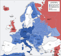
Fexeiro:Second world war europe 1941-1942 map en.png

O conteúdo da página não é suportado noutras línguas.
Ourige: Biquipédia, la anciclopédia lhibre.

Fexeiro oureginal(1 090 × 1 000 píxeles, tamanho: 216 KB, tipo MIME: image/png)

Este fexeiro ye de Wikimedia Commons i puode ser outelizado por outros porjetos. La çcriçon na páigina oureginal ye amostrada ambaixo.

Esta imagem de military map (ou todas as imagens neste artigo ou categoria) deveriam ser recriadas usando gráficos vectoriais, como ficheiros SVG. Isto tem várias vantagens; veja as Commons:Media for cleanup|imagens para rever para mais informações. Se já criou um ficheiro SVG desta imagem, por favor, carregue-o. Depois do novo ficheiro SVG ter sido carregado, substitua aqui esta predefinição pela predefinição {{vector version available|nome da nova imagem.svg}}.
Kaarten van de geschiedenis van Europa
BCE
aC

Weichselian ice age (c. 113,000–9700) · Neolithic expansion (c. 7000–4500) · Middle Neolithic (c. 4500–4000) · Late Neolithic (c. 4000–3000) · Copper Age – Corded Ware culture (c. 2900–2350) · Copper Age – Bellbeaker culture (c. 2800–1800) · Early Bronze Age – Unetice culture (c. 2300–1600) · Late Bronze Age – Urnfield culture (c. 1300—750) · Migrations (c. 1000–100) · Hallstatt & La Tène cultures (c. 800–100) · Roman Republic (510–40) · 220 · 218 · 200 · 201–100 · 58 · 49 · 39 · 30 BCE–6 CE


CE
dC

14 · 14–37 · 60 · 60 · 69 · 80 · Migrations 100–500 · 117 · 117 · 125 · Migrations 150–774 · Economy 180 · 271 · 293–305 · 337 · 395 · c. 395 · 400 · 400 · 450 · 457–61 · 476 · 480 · Franks 481–814 · Early Slavs 500–700 · 500 · 526 · 526–600 · Christianisation to 600 · c. 550 · 650 · Pontic Steppe 650 · 665 · 800 · Vikings 800–1050 · 814 · 843–70 · 850 · 900 · 912 · 998 · 1000 · 1000 · 1054 · 1092 · First Crusade 1095–99 · 1097 · 1135 · 1142 · 1147–49 · 1190 · 1190 · 1250 · c. 1250 · 1301-1400 · 1301-1400 · 1328 · 1345 · Black Plague 1347–51 · 1360 · 1400 · Trade routes c. 1400 · 1430 · 1470 · 1490 · 1492 · 1500 · 1519 · 1550 · 1560 · Religion 1560 · Religion 1600 · Religion 1618 · 1618–48 · 1648 · 1683 · 1700 · 1701 · 1708 · 1714 · 1721 · 1725–30 · 1739–1740 · 1740 · 1748–66 · 1783–1792 · 1787 · 1787 · 1789 · 1799 · 1812 · 1812 · 1812 · 1812 · 1813 · 1815 · 1815 · 1815 · 1818 · Ottoman Empire 1830–1923 · 1848–49 · 1861 · 1867 · 1871 · 1878 · 1890 · 1905 · 1911 · 1914 · 1914 · 1919 · 1919–29 · 1923 · 1929 · 1930 · 1940 · 1941–42 · 1942–45 · Cold War 1947–91 · 1950 · 1993–2006 · 2006 to date

(this template: · view · discuss )

Çcriçon de l fexeiro

Annotations
InfoField
This image is annotated: View the annotations at Commons
Çcriçon
Deutsch: Karte der vom Deutschen Reich besetzten Gebiete und der Kriegsfronten im Zweiten Weltkrieg, 1941/42.
English: A map of German front of the Second World War circa 1941-1942.
Ελληνικά: Εδαφικές κατακτήσεις του Ράιχ
Español: Conquistas territoriales del Reich
Data Original Image: 17 April 2005
Derivative Image: 22 December 2005
Fuonte Este ficheiro foi derivado de: Second world war europe 1941-1942 map de.png
Outor Original Author: User:San Jose
Derivative Author: User:ArmadniGeneral
Permisson
(Reoutelizar este fexeiro)
This image is a translation of the original, created and released under the terms of the GNU Free Documentation License.
Outras versões

Derivative works of this file:  Großdeutsches Reich-europe.png [eiditar]

Lhicença

GNU head Ye cuncedida permisson pa copiar, çtribuir i/ó modificar este decumiento ne ls termos de la lhicença GNU Free Documentation License, Verson 1.2 ó qualquiera berson posterior publicada pula Free Software Foundation; sin Secçones Ambariantes, sin testos de Cápia i sin testos de Cuntra-Cápia. Ye ancluída ua cópia de la lhicença na secçon antitalada GNU Free Documentation License.
w:pt:Creative Commons
atribuiçon partilhar ne ls termos de la mesma licéncia
La outelizaçon deste fexeiro ye reglamentada ne ls termos de la lhicença Creative Commons Atribuiçon-Cumpartir Eigual 3.0 Nun Adaptada.
Sós lhibre pa:
  • partilhar – copiar, çtribuir i trasmitir la obra
  • recumbinar – criar obras deribadas
De acuordo culas seguintes cundiçones:
  • atribuiçon – Ten de atribuir la outoria de la obra, de la forma specificada pul sou outor ó lhicenciante (mas nun de forma a sugerir que estes l apoian ó subscrebem l sou uso de la obra).
  • partilhar ne ls termos de la mesma licéncia – Se altarar, trasformar ó ampliar esta obra, solo puode çtribuir la obra resultante lhicenciando-la cula mesma lhicença ó cun ua lhicença semelhante a esta.
Esta marca de licenciamento foi adicionada a este ficheiro durante a atualização da licença GFDL.

Legendas

Adicione uma explicação de uma linha do que este ficheiro representa

Elementos retratados neste ficheiro

retrata Portuguese

tipo de média Portuguese

image/png

Stórico de l fexeiro

Clique an ua data/hora para ber l fexeiro tal cumo el staba naquel sfergante.

Data i horaAmostraTamanhoOutelizadorComentairo
atual16h20min de 5 de agosto de 2020Amostra de la berson de las 16h20min de 5 de agosto de 20201 090 × 1 000 (216 KB)Claude ZygielDistinguished statutes
01h00min de 28 de júlio de 2018Amostra de la berson de las 01h00min de 28 de júlio de 20181 090 × 1 000 (184 KB)JeffyPShrinking file size
08h06min de 16 de febreiro de 2009Amostra de la berson de las 08h06min de 16 de febreiro de 20091 090 × 1 000 (214 KB)Guinnog{{Information |Description=better titles |Source=*File:Second_world_war_europe_1941-1942_map_en.png |Date=2009-02-16 08:05 (UTC) |Author=*File:Second_world_war_europe_1941-1942_map_en.png: Sir Lothar *derivative work: ~~~ |Permission=see below
00h22min de 11 de abril de 2008Amostra de la berson de las 00h22min de 11 de abril de 20081 090 × 1 000 (208 KB)Sir Lothar
05h36min de 21 de dezembre de 2005Amostra de la berson de las 05h36min de 21 de dezembre de 20051 090 × 1 000 (221 KB)ArmadniGeneralA map of the Eastern front of the Second World War circa 1941-1942. The original German-language map was created by User:San Jose on 17 April 2005. It can be found here: Image:Second world war europe 1941-1942 map de.png. This image is a translat

Esta páigina lhiga este fexeiro:

Outelizaçon global dun fexeiro

Las seguintes wikis outelizan este fexeiro:

Ber la outelizaçon global deste fexeiro.

Metadados