
Fexeiro:City of London skyline from London City Hall - Oct 2008.jpg

Tamanho desta antebison: 800 × 420 píxeles. Outras resoluçones: 320 × 168 píxeles | 640 × 336 píxeles | 1 024 × 537 píxeles | 1 280 × 671 píxeles | 2 560 × 1 343 píxeles | 8 441 × 4 427 píxeles.
Fexeiro oureginal (8 441 × 4 427 píxeles, tamanho: 10,81 MB, tipo MIME: image/jpeg)
Çcriçon de l fexeiro
| Çcriçon |
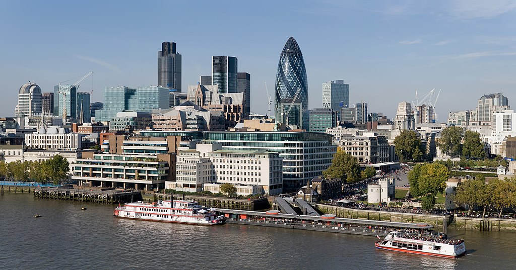
English: The City of London skyline as viewed toward the north-west from the top floor viewing platform of London City Hall on the southern side of the Thames. In the foreground: Dixie Queen and Millennium Time at Tower Millennium Pier. This is a 5 segment panoramic image taken by myself with a Canon 5D and 24-105mm f/4L IS lens. |
| Data | |
| Fuonte | Obra de l própio |
| Outor | Diliff |
| Permisson (Reoutelizar este fexeiro) |
Summary:In using this image or any subsequent derivatives of it, you are required to release the image under the same license. As such, any reproduction of this image, in any medium, must appear with a copy of, or full URL of the license.Attribution of this image to the author (DAVID ILIFF) is also required, preferably in a prominent location near the image.No other conditions may be added to, or removed from this license without the permission of the author and copyright holder.Suggested attribution: "Photo by DAVID ILIFF. License: CC BY-SA 3.0"Please review the full license requirements carefully before using this image. If you would like to clarify the terms of the license or negotiate less restrictive commercial licensing outside of the bounds of GFDL/CC-BY-SA, please contact me by email, or if you don't have a Wikipedia account you can either leave a message on my talk page with your contact details and your request, or you can contact me on Facebook. Please also send a 'friend request' to ensure that I am aware of your message. |
| Outras versões |
  |
| Localização da câmara | | Esta e outras imagens nas suas localizações em: OpenStreetMap |
|---|
Lhicença
Eu, titular dos direitos de autor desta obra, publico-a com as seguintes licenças:
La outelizaçon deste fexeiro ye reglamentada ne ls termos de la lhicença Creative Commons Atribuiçon-Cumpartir Eigual 3.0 Nun Adaptada.
- Sós lhibre pa:
- partilhar – copiar, çtribuir i trasmitir la obra
- recumbinar – criar obras deribadas
- De acuordo culas seguintes cundiçones:
- atribuiçon – Ten de atribuir la outoria de la obra, de la forma specificada pul sou outor ó lhicenciante (mas nun de forma a sugerir que estes l apoian ó subscrebem l sou uso de la obra).
- partilhar ne ls termos de la mesma licéncia – Se altarar, trasformar ó ampliar esta obra, solo puode çtribuir la obra resultante lhicenciando-la cula mesma lhicença ó cun ua lhicença semelhante a esta.

|
Ye cuncedida permisson pa copiar, çtribuir i/ó modificar este decumiento ne ls termos de la lhicença GNU Free Documentation License, Verson 1.2 ó qualquiera berson posterior publicada pula Free Software Foundation; sin Secçones Ambariantes, sin testos de Cápia i sin testos de Cuntra-Cápia. Ye ancluída ua cópia de la lhicença na secçon antitalada GNU Free Documentation License. |
Puode scolher la lhicença que quejir.
Avaliação
|
Esta imagem foi examinada usando-se o guia para imagens de qualidade e é considerada uma Imagem de qualidade.
|
| Annotations | This image is annotated: View the annotations at Commons |
Stórico de l fexeiro
Clique an ua data/hora para ber l fexeiro tal cumo el staba naquel sfergante.
| Data i hora | Amostra | Tamanho | Outelizador | Comentairo | |
|---|---|---|---|---|---|
| atual | 07h41min de 24 de júnio de 2012 | | 8 441 × 4 427 (10,81 MB) | Tim! | Reverted to version as of 12:54, 12 October 2008 |
| 12h54min de 12 de outubre de 2008 |  | 8 441 × 4 427 (10,81 MB) | Diliff | {{Information |Description={{en|1=The City of London skyline as viewed toward the north-west from the top floor viewing platform of London City Hall on the southern side of the Thames. This is a 5 segment panoramic image taken by myself with a Canon 5D an |
Lhigaçones de l fexeiro
Esta páigina lhiga este fexeiro:
Outelizaçon global dun fexeiro
Las seguintes wikis outelizan este fexeiro:
- Outelizaçon na af.wikipedia.org
- Outelizaçon na ar.wikipedia.org
- Outelizaçon na az.wikipedia.org
- Outelizaçon na az.wiktionary.org
- Outelizaçon na be-tarask.wikipedia.org
- Outelizaçon na be.wikipedia.org
- Outelizaçon na bg.wikipedia.org
- Outelizaçon na bs.wikipedia.org
- Outelizaçon na ca.wikipedia.org
- Outelizaçon na cy.wikipedia.org
- Outelizaçon na de.wikipedia.org
- Outelizaçon na en.wikipedia.org
- Tower Millennium Pier
- Wikipedia:WikiProject UK geography
- Wikipedia talk:WikiProject UK geography
- User:Diliff
- Portal:London/Pictures/Wikipedia featured pictures
- Wikipedia:Featured pictures/Places/Panorama
- Portal:United Kingdom/Featured picture
- Wikipedia:WikiProject UK geography/Announcements
- Wikipedia:Featured pictures thumbs/13
- Metropolis
- Wikipedia:Featured picture candidates/October-2008
- Wikipedia:Featured picture candidates/City of London skyline
- Wikipedia:Wikipedia Signpost/2008-11-08/Features and admins
- Wikipedia:Wikipedia Signpost/2008-11-08/SPV
- Wikipedia:Picture of the day/June 2009
- Template:POTD/2009-06-08
- User talk:Diliff/Archive6
- List of central business districts
- Wake Up to Money
- User:Quibik/Montage
- Portal:London/Featured picture
- Portal:London/Featured picture/12
- User talk:Sabrebd/Autoarchive 4
- Talk:United Kingdom/Archive 27
- User talk:Ottoniel B
- Portal:United Kingdom/Featured picture/47
- Talk:London/Archive 11
Ber la outelizaçon global deste fexeiro.